Titiroa. An old Maori word and the name of an incredible mountain I see every day. Locals and visitors alike remark on its dirty white peak, which looks like snow to the uneducated eye; really, Titiroa is covered with weathered granite that has worn away to sand and left behind eerie rock formations, reminiscent of the red spires of Utah's canyon country.
According to a book of Fiordland place names,
titiroa means
a long wedge (for splitting wood), which the book says is a good descriptive name for this long mountain massif. Of course, we didn't look up this definition till after we climbed the mountain, and now it doesn't seem fitting for so majestic a place. I like our other self-made theory: titi- is a common word for a bird (like titipounamu, which means "greenstone bird" and refers to the small green riflemans that flit around Kiwi forests), and -roa means something big and great. Maybe the mountain was names for some great mythical bird or god that impressed the Maori of the area. That certainly seems more fitting, a name that carries some weight.
Our climb of Titiroa was a summer-long dream, which I never really expected to manifest itself. Even after I arranged for a three-day weekend in the middle of April with Lyn, so we could take on this adventure, it didn't seem real. And suddenly, the day was upon us, and our motley crew of five set out to climb the great peak to our south.
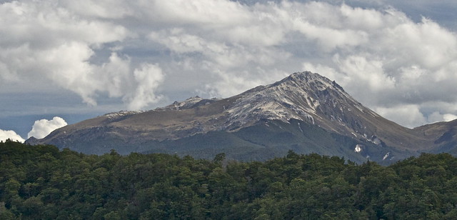 |
| Mt Titiroa from below, at Lake Manapouri (beautiful photo courtesy of Flickr). |
 |
| Our route on days 1 and 3, past Hope Arm Hut and into camp along the Garnock Burn. |
 |
Team Awesome at Pearl Harbour, waiting to take the water taxi across the Lower Waiau River to the start of our adventure.
|
 |
| (clockwise) Jonny, Mike, Kat, Pi'i, and Lyn. |
 |
| Beech forest on the way to Hope Arm Hut. |
 |
| Beautiful forest. |
 |
| Young falcon met its bitter end close to the track... its talons were the telltale sign among lots of feathers. |
 |
| Felt like a fairy tale. |
 |
| Fantail saying hello. At one point I had four or five of them flitting around and following me down the track. Of course they moved to quickly for a real good photo op when they had their tails fanned out, but this'll do. |
 |
| South Island robin. |
 |
| The valley of the Garnock Burn. |
 |
| Walking upriver to camp. |
 |
| First view of Titiroa! |
 |
| Whio (blue duck) friends that came to visit. They whistled at us through the evening, because I think we camped close to their roost. |
|
|
Setting up camp. Took four of us to carry that log.
|
The next morning dawned chilly and foggy. I looked up the hill to see what I could see and I could see nothing. Just gray and mist. We all told ourselves it would burn off, but that didn't turn out to be exactly right. But what did happen I wouldn't trade for the world; we actually hiked out of the clouds. Something about being up above them gave our adventure a more solitary and elevated feeling, like we were on top of the world. I've never seen anything like it before. While at the start of the day I would've said my ideal weather was crystal clear, now I look back and am so glad it turned out the way it did:
 |
| Our route on day 2, up the big hill all the way to the summit at 1715 m (5627 ft) and back to camp. |
|
|
Heading up on summit day. Following deer trails through the bush.
|
 |
| Pausing for a breather at some of the many bluffs we passed. |
|
|
| Summit! Not. Our first break out of the trees, and the incessant clouds as a backdrop. |
 |
| Dewy spiderwebs are good excuses to stop and catch one's breath. |
 |
| Finally above the bushline and looking at some blue sky...thank you weather! |
 |
| Yus. Also Pi'i told us she had a dream last night about climbing somewhere high with us and being surrounded by snow and seeing a rainbow overhead. Obviously the dream was prophetic but instead of snow it was the weathered granite sand of Titiroa. |
 |
| First of many strange rock formations. |
 |
| Looooky that blue sky. |
 |
| Getting above the clouds. |
 |
| We climbed up over a hill and all the sudden...bam. Hello, Titiroa. We're really going all that way up there? |
 |
| I'm walking and I hear Jonny say, "Take a picture, quick!" I look up and see this. Crazy kid. |
 |
| Just about the coolest thing I've ever seen. Looking back the way we'd come. |
 |
| View west over the Hunter Mountains. |
 |
| Unnamed tarn to the east of the ridge. Apparently makes a good camping and swimming spot. Next time. |
 |
| Lyn on the tippy top. |
 |
| SUMMIT. |
 |
| Team Awesome made it! |
 |
| Of course, I blinked. |
 |
| On the descent. Yes, it's sand. Just about the nicest downhill ever. |
 |
| West. |
 |
| Sunrise the next morning. |
 |
| Home sweet home. Strange how even though we were only out for three days, it seemed like ages longer, and all the cares and troubles I had before leaving just melted away. Aside from the views, this is why I love nature. |
 |
| Our route on summit day: pretty much straight up the hill (explains why it was so darn steep) and then along the ridge, past about twenty false summits and up to the real one. |
 |
| Something about the grass growing out of the footprint, I love. |
 |
| A nice gift from one tired tramper to the rest of us after struggling uphill out of the Garnock Burn on the way back home. |
 |
| Snack and fantail break. |
 |
| Almost back to Hope Arm Hut. |
 |
| Glorious lunch on the beach of Lake Manapouri. Would've been even better if there hadn't been a group of hunters having races in their speed boats. |
 |
| We made it back! Waiting to be picked up by Mike in his boat. This little log was followed by ice cream from the local shop and the splurge of social activity that is Manapouri at 4 pm - mail time. After chatting to a few local characters outside the shop/post office, we went for a quick dip in Lake Manapouri before the drive back home. A few hours to rest and take a shower, and then we reconvened at Pizzeria Da Toni's for some delicious post-mission grub. What a way to be. |
All photography copyright Kendall DeLyser unless otherwise noted.


