Yesterday I got back from a four-day adventure on the
Milford Track. By far the most popular track in Fiordland, it runs for 54 kilometers (33.5 miles) from the northern end of Lake Te Anau, up and over Mackinnon Pass (1154 m / 3786 ft), and down to Milford Sound. Here's a map:
The first day of the track is relatively short - you spend 30 minutes on a bus, 75 minutes on a boat, and about an hour and a half walking to the first hut, covering a distance of 5 km (3.1 mi).
 |
| On the boat to the start of the track. |
 |
| At the beginning! |
 |
| The first of many swingbridges on the track, over the Clinton River. |
 |
| The first day's track takes you through the beech forest. |
 |
| A little side track takes you to these wetlands close to the end of the first day, near Clinton Hut. Mt. Sentinel stands in the middle in the distance - our path for the next days winds around its left side. |
 |
| The components of Clinton Hut (bunkroom, bunkroom, kitchen), the first on the Milford Track. There are also flush toilets with cold running water, and the kitchen has gas stoves available for cooking. |
Clinton Hut is where the tourists stay, with 40 beds available each night. Since the hut was full, I stayed with the conservation ranger/hut warden Peter Jackson (not the filmmaker, but still an interesting fellow) in the private staff quarters. Rangers on this track work for a week at a time, and since the track is relatively remote, they live at the hut for the week that they're working, and then leave to make room for their offsider for the week that they don't work. Peter took us all on a nature walk around the hut, pointing out different types of trees, ferns, and mosses, teaching us the Maori names as well as the English ones.
The first evening it rained throughout the night, which is typical weather for Milford, but the next dawned with the promise of sunshine. As it turned out, we didn't get rained again for the rest of the walk, but as I'm told, that's not very common. So I got lucky.
 |
| Bianca (Netherlands) and Barbara (Canada), the two ladies I walked with, on the trail through the forest on the second day. |
 |
| Clear weather over the Clinton River. |
 |
| Breaking out of the trees on a side track. |
 |
| The scar left by a landslide, a very common occurrence in the Milford area because the steep rock doesn't provide a very stable place for plants and trees to grow. One good rainfall can bring the vegetation crashing down from the cliffs, leaving a barren patch that takes years to regrow. This slip happened in 1982. |
 |
| Bianca on the trail through the area cleared by the slip, making our way up the Clinton River valley. |
 |
| First view of Mackinnon Pass, our obstacle for the third day. |
 |
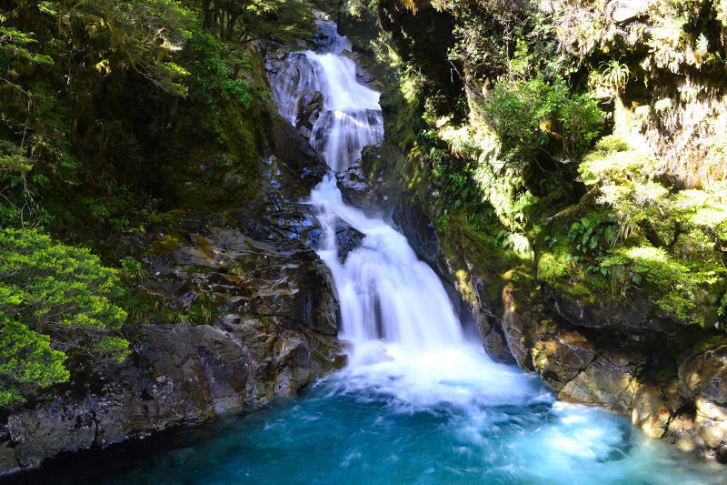
| Waterfalls into Hidden Lake. A typical feature of the Clinton valley. |
 |
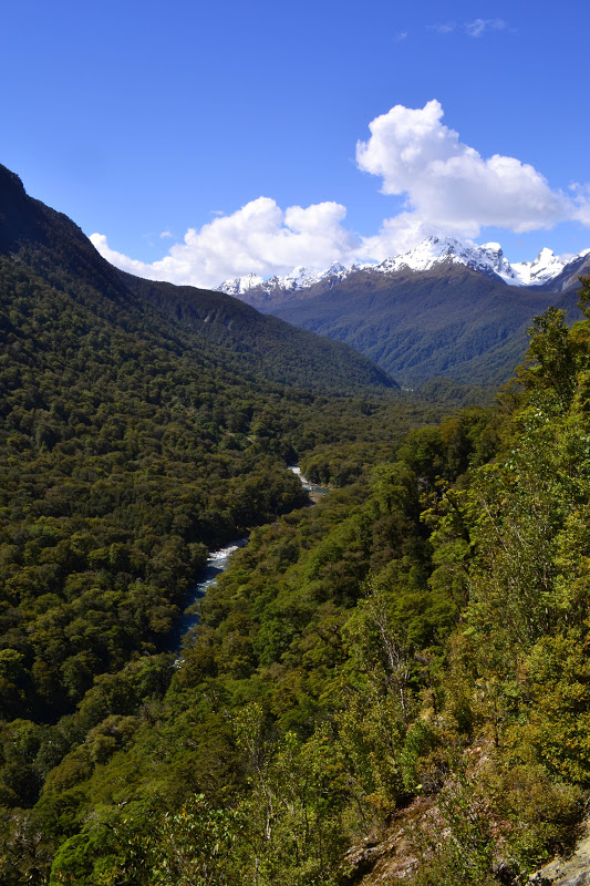
| Looking back down the Clinton Valley the way we'd come. |
 |
| Lunch at a dry Pompolona Creek. Imagine this when it's been raining... |
 |
| Bianca, through more ever-changing vegetation. |
 |
| A little climb at the end of the second day towards Mintaro Hut. |
We reached Mintaro Hut after walking 16 km (9.9 mi) early on a sunny afternoon, and since the weather's always unpredictable around Milford, we decided to head up to the saddle of Mackinnon Pass to take advantage of the clear skies and see what we could see. The next day turned out to be clear as well, so we were blessed with an incredible view twice, once in the afternoon and then once the next morning.
 |
| Mt. Cook Lillies, high-altitude loving plants. |
 |
| The view from the trail during the last part of the ascent. |
 |
| The view from the top, looking down into the Arthur River valley, our destination for the next day. |
 |
| Enjoying the view from the "12 Second Drop" rock. |
 |
| Monument to Quintin Mackinnon, the brave man who discovered the pass and pioneered the Milford Track with Donald Sutherland. The shoulder of Mt. Elliot (1990 m / 6529 ft) on the right. |
 |
| Mt. Elliot and the Jervois Glacier. |
 |
| Back at the bottom - Lake Mintaro, the source of the Clinton River, and the namesake of Mintaro Hut. |
The second night, I again stayed with the ranger at Mintaro Hut, named Eddie. He was also hosting a few others, some geologists and a DOC employee who were in the area surveying the rockslide potential around the hut to follow up on a report from a few years ago. We had a good time sharing food and conversation. The next morning dawned beautiful and clear, and Bianca and I took our time on top of the pass, sitting and enjoying the sun and the view.
 |
| Looking down on the saddle and the Mackinnon Monument from a little ridge. |
We were entertained by the local clowns, keas - alpine parrots about the size of a cat and with as much cheeky personality. They're smart birds and they've figured out that if they come to where the tourists are, they're bound to get attention, and probably food too. A group of Koreans on the track with us was throwing food to the birds...grrr...but the keas might've even preferred playing with everyone's backpacks, testing everything to see if it was edible.
 |
| On top of the Mackinnon Monument. |
 |
| They're not shy so it wasn't hard to get close. |
A few kea that wandered towards us must have been a family - two adults and a teenager - and the parents would take turns charging the kiddo to make him fly. They were all perched on the cliff's edge and when the youngster took to the air, he had a strong enough headwind that he'd only flap his wings a couple times before landing again. Made for some incredible images.
 |
| Curious about my pack. |
 |
| The Arthur River valley, our destination for the day, winds around the right side of the mountain. Everything in this area was glacially carved, and the pass provided a great vantage point to admire the glaciers' work. |
 |
| Mt. Elliot and the Jervois Glacier. |
 |
| Top of Mackinnon Pass (1154 m / 3786 ft)! |
 |
| The Clinton River valley, our path for the first two days of the track. |
 |
| The descent into the Arthur valley - we had to use the emergency track (really just an alternate route) to take us farther away from Mt. Elliot and the Jervois Glacier, as they still posed a significant avalanche threat, especially with the warmer weather. |
 |
| One of the many falls on the Roaring Burn, which followed us on our descent. |
 |
| Barbara on a swingbridge over the Arthur River. |
 |
| The Sutherland Falls (580 m / 1904 ft), the highest falls in New Zealand. There's normally a side track that leads to the base of the falls, but it's currently closed because of a massive rockfall from high on a cliff over the trail. As cool as it might have been to stand behind the falls, it's definitely not worth the risk of a huge rock falling on your head. |
 |
| Swimming hole near Dumpling Hut at the end of the third day. Looks appealing, but the water was freezing and the sandflies attacked in swarms. Still, it was a refreshing, albeit very quick, dip. |
The third night was an early one, as I was tired from covering 14 km (8.7 mi) of up-and-down terrain, and my feet were hurting. Shelly, the Dumpling Hut warden, and I talked for a little while, but our yawns got the best of us around 9:30. Just as well, because the next day I had 18 km (11.2 mi) to cover and an early start to the day to make sure I made it to the end in time to catch the ferry away from the track to the village of Milford itself, at the mouth of Milford Sound. (Note: Milford Sound is actually a fjord. The difference? A fjord is a glacial valley filled with ocean water. A sound is a sunken river valley flooded by the ocean.)
 |
| Through the rabbit hole? |
 |
| Bianca on a swingbridge over the crystalline Arthur River. |
 |
| Arthur River. |
 |
| Beautiful Mackay Falls. |
 |
| Rare blue duck, or whio (pronouced fee-oh), on Poseidon Creek. Their Maori name comes from the strange airy whistling sound they make - it sounds like they're calling whio, whio. |
 |
| The Rock Cutting, the only climb on the last day cut straight from the rock by contractors when the track was first built. Some of the workers' names are carved into the wall. |
 |
| Giant's Gate falls. Can you find Ian in the lower righthand corner? |
 |
| Cool fern. Looks part violin part caterpillar. |
 |
| At the end! |
Just because it's not an adventure if nothing goes wrong...the Milford Road (back to Te Anau and home) was closed when we got off the track! The road is heavily surveyed for avalanche and rockfall danger because it's been subject to lots of each event over the years, and it seems that while we were walking, they had spotted a worrisome rocky overhang, about the size of five rugby pitches (or football fields), that seemed poised to let go and come crashing down the mountainside onto the road at any moment. It had previously been covered by snow and ice but the couple warm sunny days we enjoyed melted enough of the covering to expose the danger, and it seems to me that it's only a matter of time before it does all let go, seeing as it's only more snow and ice holding it together. As it was, we all had to spend the night in Milford unless we wanted to pay for a helicopter or plane ride. I was put in touch with Shaun, the manager of the Real Journeys cruise company, and he took good care of me - he offered me the extra room in his house and fed me until the next day, when I drove a DOC car that had been left in Milford back to Te Anau as part of a convoy they let through at 11 in the morning (before the overhanging rock had warmed up enough to melt and potentially fall). Waiting at Shaun's house that morning before leaving, the clouds began to clear and this rainbow appeared, along with the (not so) lovely sandfly on my camera lens.

All photography copyright Kendall DeLyser