This was by far my favorite part of our roadtrip. We went bush for five days with no technology, no stresses, and no worries other than keeping warm, eating enough, and getting to the next hut before dark. The weather cooperated and even gave us a sunny day when we really wanted it. The scenery will knock your socks off. So without further ado, the Rees-Dart track.
 |
| It's no wonder people love this area (us included) - just look at all the mountains and glaciers! |
 |
| After an early-morning shuttle with Alan of Glenorchy Journeys to drop our car at the other end of the track, we were dropped here at the Muddy Creek carpark to start our walk. Alan's parting words to us: "Now just keep walking until you see your car!" |
 |
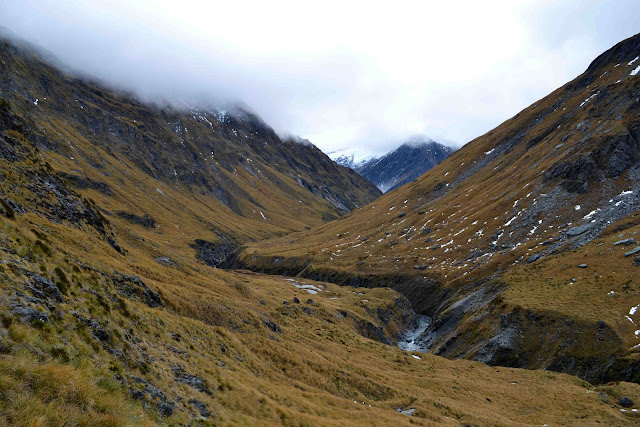
| The first bit was through the Rees Station (aka big grassy flats with lots of cows). Nice easy walking. |
 |
| Once we reached the Mt Aspiring National Park boundary, we once again found ourselves surrounded by beech trees. |
 |
| The last push to our first hut. The moment we saw the mountains, my energy revived itself and I got downright giddy. |
 |
| Hut number 1: Shelter Rock Hut (lower right corner). |
There was no one else in the hut and no firewood in the shed, so we ditched our stuff inside and set out to collect what sticks we could from a small patch of forest nearby. We collected enough to half-fill the woodshed, so that the next poor soul who wandered through wet and cold could start a fire straight away. AND I learned how to chop wood properly. Then we started our own fire and ate delicious warm dinner. It's the little things.
 |
| Looking back down the valley the way we'd come the next morning. Slowly climbing to the Rees Saddle. |
 |
| Rees Saddle in sight (the track goes up the left side of it just by the big rock wall). |
 |
| Rees Saddle (1471 m / 4826 ft)! |
 |
| Our next hut is at the other end of this valley. |
 |
| We found the glaciers! |
 |
| Successful crossing of Snowy Creek. You can see to Lyn's left the wood supports for the bridge that normally crosses this creek. During winter the bridge is removed, and we were somewhat worried about how to cross the creek since it's in a bit of a gorge. But when we got to the site of the bridge, we realized it would be pretty simple to boulder-hop across and not even get wet feet. Sweet as. |
 |
| Looking back up Snowy Creek towards the Rees Saddle, the way we'd come. |
 |
| Hut Sweet Hut number 2: Dart Hut. |
The next morning, we were greeted by a gray sky but no cloud. As the day continued, the sun came out to shine on our day-walk mission up to Cascade Saddle. Hands down, the highlight of the trip:
 |
| Looking up the Dart Valley from the hut. Beautiful start to an epic day. |
 |
| Hesse and Marshall Glaciers on the south face of Mt Edward (2620 m / 8596 ft). |
 |
| Glorious sunshine and interesting glacial deposits. |
 |
| Terminal face of the Dart Glacier (birth of the Dart River, which empties into Lake Wakatipu near Glenorchy - so we've now seen this river from source to mouth). This glacier used to extend all the way to Lake Wakatipu and down beyond Queenstown - now it's retreated all the way up here. Everything we walk the following days, and our drive back to Queenstown at the end, was once under the ice of this glacier. WOW. Mind blown. |
 |
| Head of Dart Glacier beneath the Park and Pench Glaciers and Mt Maori (2585 m / 8481 ft). |
 |
| A very happy Kendall with the Dart Glacier behind. |
 |
| Our original goal was only to walk to the face of the glacier and turn around, so as not to push ourselves too hard, but then we saw that Cascade Saddle was only 2 km away and clear of snow, so...we went for it, of course. Best decision ever. |
 |
| Mt Edward and the Dart Glacier reflected in a little alpine tarn. Cold enough to still have ice, but this all melted by the time we came back down. |
 |
| An avalanche we saw on our climb to the saddle (right in the middle of the picture). |
 |
| Gaining height to the saddle. Taking pictures is a great excuse for catching your breath... :) |
 |
| Breathtaking again, but not because of the climbing this time. Looking over the other side of the saddle to the Matukituki Valley with Rob Roy Peak just over my right shoulder. This is the same valley we saw when my mom and I walked to the Rob Roy Glacier. |
 |
| I love this picture. Lyn with the Dart Glacier behind. |
 |
| The truly glorious view from Cascade Saddle (1524 m / 5000 ft). Dart Valley and Glacier on the left, Rob Roy Peak and Matukituki Valley to the right. |
 |
| New Zealand falcon perched on a cairn on our way back to the hut. |
We stayed at Dart Hut again for the evening, this time joined by a guy from Cleveland named Aijay, who was walking on his own. It was nice to have another person to talk to for an evening, but after our exciting day I doubt we were great company. Needless to say, it was an early night for Lyn and I, but a restful one knowing that the most difficult part of the walk was behind us and two days of gradual downhill awaited us. Little did we know...
 |
| More pretty forest. This part was fine. |
 |
| Crossing the mess left by massive floods in January when the Fiordland/Mt Aspiring area got absolutely pounded with rain. Compare the current size of the stream to the size of the whole riverbed and imagine the amount of water that must have been running through during the floods....your face looks like Lyn's now. |
 |
| Looking back up Cattle Flat, the worst section we walked. 4 km of up-and-down and hard-packed ground. Ugh. Dislike. |
 |
| So relieved to see hut number 3: Daley's Flat Hut. Not so relieved to see other people there - a Kiwi/British family with two kids and heaps of food. They cooked some burgers shortly after we arrived. Even to my vegetarian palate, the smell was tantalizing and cruel. Time to get out of the bush, eh? |
 |
| The only challenge of our final day: climbing up and over Sandy Bluff. Complete with handrails for the faint-of-heart or slippery conditions. Thanks, DOC. |
 |
| Looking back up the Dart River from Sandy Bluff. |
 |
| Another massive slip that must've also happened during the January storms. You can see water from the river pooling up in the lower right corner. |
 |
| Once it passes through the debris from this slip, the water turns gray. Compare the water in the pool under the rock (top of the photo) with the rest of the river (bottom of the photo). |
 |
| At the end of the track! Now another 45-minute walk to the car, which we parked farther away at Dan's Paddock because of the chance of rain turning the road into a 4-wheel-drive track. Turned out to be an unnecessary precaution, but better safe than sorry. |
Contented with our adventure and glad to be finished, we spent one more night in Glenorchy at Radka's house and then headed back through Queenstown and northwards to start our zig zag across the northern half of the South Island. Check it out
here.


BRAVO !
ReplyDeleteThanks for the Update, Tiger.